Pages

Showing posts with label Desert. Show all posts

6.28.2013

TULE LAKE #7


Cool Cave!


Lava Beds National Monument is as much about what's underground as above. With over 700 caves the Monument has largest concentration of lava tube caves in North America. Tennessee takes top honors for total number of caves of all kind as it averages 4 for every square mile in the state. This is Valentine Cave, so named for the date it was discovered in 1933.


The ceiling varied from smooth to stippled, as above. In the small area we explored near the entrance, portions of the cave roof were iridescent when hit by light. In another area, you could see where chunks had not long ago fallen off. You want a quick dose of spooky? Just turn your flashlight off.


Trying to persuade those a wee bit afraid of the dark. Better flashlights would have helped.


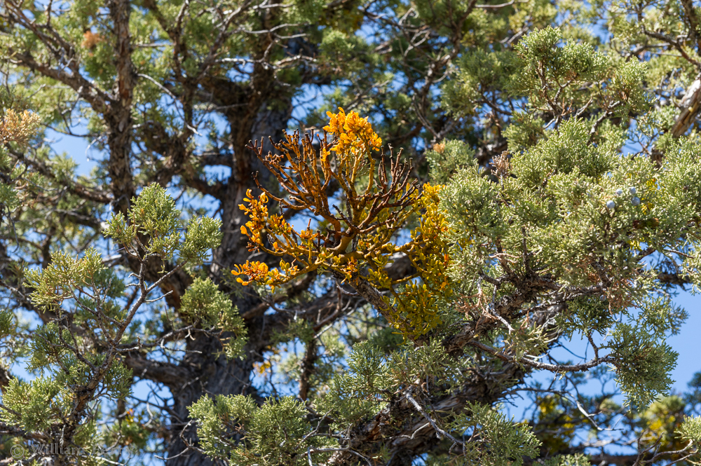
Whether is is a function of the cave or something else, we noticed a number of Juniper trees near the mouth of Valentine cave with a parasitic growths.


A closer look and it appeared to be mistletoe-like.


Something new to me - "Wag Bags." No need to explain further.

6.25.2013

TULE LAKE #6


Facing West


Sunset on "The Peninsula" and a revelation of different activities than on the east face. Less than 100 years ago the waters of Tule Lake surrounded this prominence.


Low to the ground and up close, first to be noticed are a long parade of petroglyphs. The Native Americans who predated the local Modoc and Klamath bands of tribes left these behind.


Coming by canoe, they paddled out to this place and a left what is now an indecipherable record of their existence. People who know this field of study, admit being puzzled by their meaning. When I first saw these some years ago, they were unprotected by this fence.


Watching over this heritage for perhaps as many centuries has been a series of birds. This Great Horned Owl awaits the dark to begin foraging.


For how many seasons have these big birds been here? Who knows but you can certainly pick out all the rodent skulls at the bottom of the cliff face.


Just as the sun is setting we see the return of a Prairie Falcon. There is a small lizard or rodent in its beak. 


We can't see its nest until it lands as they are pretty well hidden in the countless crevices. Suddenly the falcon flares and does a pinpoint landing at the edge its aerie. Quite a show. Quite a place.


4.19.2013

FLOWING SANDS


Shifting Light


This was not the only photographer out at dawn to shoot the Mesquite Sand Dunes. 
I guess I shouldn't have been surprised by the several dozen shooters out early. I was one of them.


As the light changes, so does the color.
The little dots are other photographers that got up earlier than I did to climb out onto the dunes.


The geometry of a sand dune features ever changing patterns within patterns.


4.18.2013

A FOREST IN THE DESERT


Joshua Trees


So named as early Mormon emigrants saw, in the shape of some of these large yuccas, Joshua with his arms thrown to the heavens. Ranchers and miners used the sharp pointed leaves as fencing and the trunks for burnable fuel for early ore smelters. Even earlier inhabitants, Indians, used the leaves to make woven baskets and sandals. The seeds are edible.


Though not what you and I might typically call a forest, they do grow in groves. Healthy trees can often last 100 years and some have been found that are 1,000 years old. Root systems can spread 30 to 40 feet outward. Though there were no big yuccas visible here, they can grow to almost 50' tall. 

4.15.2013

FLATTER THAN FLAT


Racetrack Playa


Tiny as ants, these visitors are out on Racetrack Playa. Though "playa" is Spanish for beach, in geology it means the flattest possible natural surface. This is also a near-permanently dry lake.


What the surface of Racetrack looks like up close.


In the middle of this 2.5 mile long oval is this excretion of rock called, what else but, "The Grandstand." The day I visited I was surprised to find rock climbers tethered to a boulder or two. 


There is only a 1.5 inch differential over the playa's entire 3 square mile surface. You may have read about "mystery rocks" that move and leave tracks across the playa without human intervention. Best educated guess comes from NASA. Winds are very strong in this narrow valley. When an infrequent rain hits the playa, it turns the hard pan into shallow silt. Stiff winds follow and can move the stones across the surface and cause the weight of the rock to carve its path on the playa.


4.12.2013

SO THAT'S WHERE THE NAME CAME FROM


Teakettle Junction


This colorful bit of remote humor is in nice relief from the starkness that is Death Valley. 
Teakettle Junction is on the way to the Racetrack - which is the next stop on the blog too.


4.10.2013

UBEHEBE CRATER


Death Valley's Volcanic Past


No matter where you stand it is difficult to convey the size of the bowl that is Ubehebe Crater. 
This volcanic eruption is relatively new - just 2,000 years old!


The crater does show its age in a different way. 
Pronounced as it looks, U be he be, each layer of rock represents several millions of years in the building of the earth's crust.


This Google Earth screen capture conveys a little bit better the size. 
It is one-half mile wide and over 700 feet deep. Other volcanic eruptions are visible as well.

4.07.2013

MOSAIC CANYON


Marbleous!


Like a multilayered wedding cake, Mosaic Canyon is a confection but one made of stone.


In places the rock looks rough and brittle. Adjacent deposits though are hard and as beautiful as some of finest Roman marble. 900 million years ago magnesium rich limestone deposits (called "Noonday Dolomite") were laid down then buried deep. The depth also produced great pressures and temperatures that caused the limestone to metamorphose into marble. Tectonic forces pushed this remade material to the surface and you can see this unique layer in the canyon.


It doesn't take long to hike up Mosaic Canyon to see its wonders. 
The trip back down features a different beauty as the distant desert floor commands your view.


Inhospitable as this dry canyon first appears, there are pockets of hardy greenery. Spiny and waxy, this Rock Nettle somehow thrives and survives. Despite its thorny appearance, blossoms are pleasingly fragrant.


4.04.2013

SCOTTY'S OTHER "CASTLE"


Where Legends Really Reside


A man's home is his castle, or so it is said. Not for Walter Scott, the "Scotty" in Scotty's Castle. When the gates were closed, Scotty didn't bunk down here if he could avoid it. For many years Scotty was whomever other people wanted him to be: a cowboy in Buffalo Bill's Wild West Show; a huckster, verging on the criminal, for low-grade mines and finally, entertainer for eccentric Albert Johnson's guests. It was Johnson's vision and money that built Scotty's Castle. The real Scotty was an ornament.


In some respects Albert Johnson was an honorable man and more than likely became one of Scotty's few real friends. Johnson built not only the Castle but also the house that Scotty got to live in and finally be himself.


Unusually plush for a simple desert structure, considering it was built in the late 1920s. It was constructed with 2x6 insulated walls and clad inside and out in redwood. Scotty's real home was truly his castle.


Here he could be himself. And that self was a slob, as this one of many historic photos indicates. The National Park Service has obviously cleaned things up. The tour is not often offered. Indeed there were only 3 of us that met the ranger for the mile hike to Scotty's home.


Both the Castle and the cabin share the same method of fencing that has been in place for almost 100 years. The wire fence has never had to be replaced as rust is held in check by the remarkably low humidity and lack of rain. The fence also surrounds both properties. The "S" & "J" stand for Scott and Johnson. From the hills behind that fence springs give up 420 gallons per minute. That's what the fence protected.


With the same fencing as mute evidence in the background, our guide, Ranger Scott Combs, shows how Albert Johnson defused the barricading of the water supply for those who once lived or ran animals in the area. He built the stone structure visible in both the photo and behind our guide. It was a catchbasin for a water pipe that delivered water to those outside the fence. That is Walter Scott and Albert Johnson by the cistern.

At one time, Johnson and Scott cleared a 5 acre plot and for one season planted and harvested alfalfa in order to meet government requirements for homesteading the land.


Characters and charlatans come and go, but what is almost ever present is the animal life that surrounds us, all the more remarkable in Death Valley. The National Park Service chooses not to use traditional bait (which may kill other critters) but rather the lure of a nesting material (cotton). Our guide told us that in three years giving this tour in the Park, he's never seen a trap sprung.


3.27.2013

DEATH VALLEY HUB


Furnace Creek


In the desert mulepower beat horsepower. More often than not mules beat both horses and oxen in getting the job done. It took 20 mules to pull the train of wagons above and it was the Pacific Coast Borax Company that made the "20 Mule Team Borax" name famous. 

Such was the mystique of Death Valley that the firm even created and sponsored "Death Valley Days", which was dramatization of true stories from around the early West. Heard first on the radio from 1930 to 1945 then seen on TV from 1952 until 1975, the TV program was at one time hosted by Ronald Reagan before he got into politics.


One of the few places for fuel in Death Valley National Park and the only place for diesel. Even if you had a mule, you'd still have to carry a lot of water. That's why, in the preceded photograph, every wagon train out of here trailed a big tanker of water.


Of course, there's always a bike. Some folks we talked to at our campground did bring their own bikes and got a rude shock the day they rode. It was the first day of spiking temps. Bad enough their thermometer read over 100 degrees when they climbed up to their turnaround point, but the wind came up and they had to pedal to go back downhill.

Expect the unexpected in Death Valley.


3.23.2013

DEATH VALLEY DRY


And This Is In Winter


Four days before we arrived there was quite the rainstorm. Over a 1/2" fell, which represented about a quarter of what they get all year. Within days, the once flooded washes looked like the above image.


Almost 4:15 in the afternoon and the outside temp was over 96. Note the 9% humidity. Four more degrees and the little guy goes nude. The low humidity made the heat a bit more bearable but it was a surprise to us that it got so warm in mid march. Incredibly enough the record for March is 103ยบ.


It doesn't take long for life to pop back up.


Due to clouds we never got to see the comet but a few of the sunsets were memorable. This image of a portion of the Funeral Mountains was was "painted" to resemble the way many landscape painters see the desert. 


3.21.2013

Tonopah


It's All Mine


With less than 3,000 people Tonopah ought not to have such a big town look. You can credit silver mining as the primary cause. A map of all the shafts and tunnels would show you an underground that looks like swiss cheese. Over 1.5 million in silver bullion was produced in the early 1900s. The town went bust during the depression but not before the downtown developed the character it has. As an indicator of its return to better economic health, the Mizpah hotel, at right, has been restored and turned into a very nice boutique hotel.


A new boom is on in mining and construction. This jumble of RVs and manufactured housing is mostly for all the new workers drawn to the area. The housing units come fully furnished. Many of those staying here work on the construction of a new solar array collector about 15 miles north of town. Others work at the Tonopah Test Range where the Navy has developed the F-117. Renewed interest in both gold and silver also continues to draw interest and investors.


Where once there were miners, there were also cattle and dairymen to supply them. Though this barn is nearly 100 years old, the dry air of the desert has helped preserve it.


The provenance of this roadside structure is unknown but with lumber being scarce, masons found good work in Tonopah. The town also benefits today by being the half way point between Reno and Las Vegas. The town has also one of the best mining museums found in the West.


3.20.2013

BOMBS AWAY


Hawthorne, Nevada


You are looking at dozens of the 2,427 ammunition and bomb bunkers spread out over 226 square miles of Northern Nevada desert at the Hawthorne Army Depot. Proclaimed as the "World's Largest Weapon Stockpile," the Depot also manufactures armaments. Rather scary but one of the missions of the base is to provide ammunition "to be used after the first 30 days of a major conflict."


If you got it, flaunt it. This is the Hawthorne Ordnance Museum located in town.


It doesn't hurt to have a little humor in dealing with such a serious subject. 
Someone has married up a conning tower to what was a torpedo and added a little paint.


This is such a vast place that a wide shot can't even give you a sense of the size of it all. The very first image at top is a small segment of this image and this wide shot is only part of what can be seen. My father spent some time here in training for his role as captain of a munitions company that deployed to in Europe during WW II. This base was the staging area for most all of the bombs, rockets and ammunition for the entire war effort.

Sadly the Depot was in the news recently. 7 Marines were killed during an explosion while in training this week.